
 You will be based in Letterfrack in the heart of Connemara, less than 5 minutes walk from the start of the Diamond Walk in Connemara National Park and in striking distance of thousands of acres of mountain, heather and bog walks. You will be based in Letterfrack in the heart of Connemara, less than 5 minutes walk from the start of the Diamond Walk in Connemara National Park and in striking distance of thousands of acres of mountain, heather and bog walks.
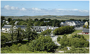
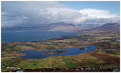
Heatherhill cottages are set in a beautiful location at the edge of Letterfrack village. The village dates back to the early 1800’s with much of its distinctive older developments taking place during and after the famine in the late 1840s and being initiated by the Ellises and their Quaker contemporaries. Today it is a small, modern village with a selection of pubs, restaurants, shops, the Connemara National Park and a college for woodwork design. Much of its interesting history is in evidence with buildings now being used for modern purposes. It is also well-known for its music and art and several festivals take place each year which focus on local art and music.
The following is a sample of walks and treks:
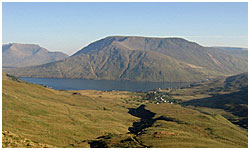
DIAMOND HILL (BINN GHUAIRE)
 Starting and ending at the Visitor Centre in Connemara National Park, Diamond Hill is a circuit consisting of two circular loop trails - Upper Diamond Hill and Lower Diamond Hill - conjoined in the middle in a figure eight fashion. Both sections are fabulously maintained trails that have undergone extensive restoration work, completed in March 06, with extensive stone work and switch-backs through the steeper sections, and large stretches of board walk along the lowlands. Taken as a whole the entire circuit measure some 7 km. Starting and ending at the Visitor Centre in Connemara National Park, Diamond Hill is a circuit consisting of two circular loop trails - Upper Diamond Hill and Lower Diamond Hill - conjoined in the middle in a figure eight fashion. Both sections are fabulously maintained trails that have undergone extensive restoration work, completed in March 06, with extensive stone work and switch-backs through the steeper sections, and large stretches of board walk along the lowlands. Taken as a whole the entire circuit measure some 7 km.
Upper Diamond Hil
Duration: 2.5 - 3 hours | Distance: 7 km | Ascent: 442m | Difficulty: Level 2
Upper Diamond Hill trail switches its way through a rugged white-quartzite landscape, ascending to the summit of Diamond Hill, where one is rewarded with expansive panoramic vistas across all of Connemara, the Twelve Ben mountains to the North and East, far down below Kylemore Abbey and Lough, Tully Mountain to the West, and to the North the summit of Mweelrea, Connaughts highest mountain.
 Lower Diamond Hil Lower Diamond Hil
Duration: 1 - 1.5 hours | Distance: 3 km | Difficulty: Level 1
Lower Diamond Hill, measuring some 3 km, gains modest heights, enough to provide sensational territorial views, particularly of the surrounding Connemara coastline and islands, including Inishbofin, before descending back down through a placid valley, full of quietude and striking examples of Connemara's blanket bog.
Diamond Hill Trail is not particularly challenging, though highly rewarding. The trail is well sign posted and highly accessible.
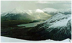
MAOL REIDH
Duration: 6.5 to 7.5 hours | Distance: 12.5 km | Ascent: 1054m | Difficulty: Level 4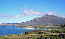
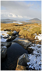
Maol Reidh is the highest mountain in Connaught and one of the greatest walks in Ireland, although it can be a long and demanding one. The mountain dominates the fjord of Killary Harbour and offers spectacular views from the summit. This walk involves a steep ascent initially and continues along a ridge to the summit of Ben Bury. Care should be taken along this ridge, especially in bad weather. You will rewarded with breathtaking views during the climb and from the summit. Maol Reidh is an excellent walk in snowy conditions and, as it is the highest mountain in Connaught, it tends to get more snow than any other mountain in the area.
TULLY MOUNTAIN
Duration: 3 hours | Distance: 8 km | Ascent: 428m | Difficulty: Level 2
 This is a relatively easy walk and a rewarding one with stunningly beautiful views. The summit offers views onto the islands of Inish Bofin and Inish Turk to the west and north west, and the Ben Choona mountain range to the south. This is a relatively easy walk and a rewarding one with stunningly beautiful views. The summit offers views onto the islands of Inish Bofin and Inish Turk to the west and north west, and the Ben Choona mountain range to the south.
Route Description
From Derryinver quay, walk towards Tully mountain for about 1 km. You should notice a grassy mound on the East side of Tully. Access to the grassy mound is through the gate or over the fence. The ascent along this grassy slope is a fairly easy one. This brings you to the cairn at the summit. This is a good place for a short break, taking time to admire the view.
Continue South West along the broad summit ridge for another 1 km or so. The summit ridge consists of small lakes or tarns, tiny valleys and rocks. Continue further west to the next summit (1 km). You can begin you ascent from this point to the end of the small road at Leitir Beg (Leitir Beag). Once you have reached the road walk along it back to the quay.
THE LEENANE HORSESHOE
Duration: 2.5 - 3 hours | Distance: 5.5 km | Ascent: 760m | Difficulty: Level 2
 This walk is probably one of the easier walks in the Maaumturk mountains. Spectacular views onto Killary Harbour await you along the route.The walk involves a steep ascent from the parking place followed by a gentle route along a grassy ridge. However, good navigation skills are needed (as with all walks) on this route, particularly in bad weather. This walk is probably one of the easier walks in the Maaumturk mountains. Spectacular views onto Killary Harbour await you along the route.The walk involves a steep ascent from the parking place followed by a gentle route along a grassy ridge. However, good navigation skills are needed (as with all walks) on this route, particularly in bad weather.
Route Description
Park near the Hotel just outside Lenanne village on the N59. The ascent is a rather steep one, having to negotiate a number of small rocky outcrops higher up. This leads you to the unnamed peak (556 m) at L863604, passing a small bog lake along the way. From here, continue south for 1.5 km over boggy ground to another unnamed peak (578 m). There is a good view into the grassy corrie of Leenaun and of Killary Harbour, Irelands only fjord, from here. Follow the ridge towards Leenaun Hill (618 m) at L874594. If you are walking here in poor visibility it is easy to make a mistake and end up passing Leenaun Hill and going onto the next ridge. There are many nice views from this peak, such as the remainder of the Maamturk range to the south, Binn Gorm to the north and Devils Mother on the North East.
The decent is a direct route northwards down the grassy ridge towards Leenane village. During winter this can be a very wet place. This area holds the record for the highest amount of rainfall annually in Ireland. You can gain access back onto the road by hopping over the fence near the Hotel, a few hundred meters west of the village.
BINN BHÁN
 Duration: 3 - 3.5 hours | Distance: 9 km | Ascent: 729m | Difficulty: Level 3 Duration: 3 - 3.5 hours | Distance: 9 km | Ascent: 729m | Difficulty: Level 3
Binn Bhán (the White Peak) is the highest peak of the Beanna Beola (the Twelve Bens). It is composed entirely of quartzite which gives its East face its distinctive pale or white colour. Access to this peak is on the small road off the main road in the Inagh Valley at L820562. Park along the main road near the junction at L820562.
Route Description
The route begins beyond the gate which is west of the farm house. Follow the path below the stone sheep fold at L813564 and continue along the valley floor of Gleann Eidhneach, for another 2 km. You then ascend the ridge between Binn Charrach (Knockpasteenmore) and Binn Bhán. This takes approximately 30 to 40 minutes. Once on top of the ridge, continue in a South Westerly direction towards the summit of Binn Bhán. Eventually, you will come across a small mountain trail which zig zags on the right hand side ( the North side) of the summit, before turning South high up, the final one hundred meters or so to the summit.
The view from the summit is excellent. One can admire the beauty of the surrounding areas, the entire Twelve Bens, the Maamturk range on the North Eastern side of the Inagh valley, and on a clear day, the Aran Islands to the south and Inish Bofin to the West.
The decent is down the South side, avoiding the crags at L788535. Care should be taken here, particularly when walking on the scree slopes in bad weather. Once below these cliffs, drop down towards the col between Binn Bhán and Binn Dhubh, known as Mám Eidhneach. Continue Eastwards and pick up the sheep trail which hangs on the lower slope of Binn Bhán. This leads you across a deep river bed, which was severely deepened during Hurricane Charlie a number of years ago. The sheep trail leads you to a moraine below the East face of Binn Bhán. It is advisable to keep to the moraine and the Northern side of the valley (away from the river which flows along the floor of Gleann Eidhneach), as it is much drier there. However, it is difficult to return to your starting point without getting wet here. Eventually you will come across the stone sheep fold, where you can pick up your original track back to the farmhouse from where you started from. Continue along the botharin (small road), to the main road, where you parked your car.
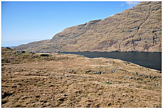
KILLARY HARBOUR FAMINE WALK
 Duration: 6 hours | Distance: 10 km | Ascent: 180m | Difficulty: Level 2 Duration: 6 hours | Distance: 10 km | Ascent: 180m | Difficulty: Level 2
This easy walk will take you along the southern shore of Killary harbour which is Irelands only fjord. The route offers stunning views of the fjord which are only accessible on foot, you will come across the ruined famine village of Foher, as well as passing cascading waterfalls which descend under the track all set against the steep craggy backdrop of Maol Reidh and its gully’s steeply descending into the fjord.
The route for the most part follows a famine relief road westwards to the harbour at Rosroe pier. At the pier it then follows along the northern shore of Little Killary Harbour on tarmac road, then back to a track as the route goes back to the Killary Harbour famine track via Salruck Pass.
Route Description
Leaving Letterfrack drive towards Kylemore Abbey, the first left turn junction after the abbey is approximately 6km further on, this is signposted for a dive centre and others. Continue a further 200m meters and on the left you will see a minor road, a stone at the side of this road is marked 'Bunowen'. This is the start of the route.
(Outward Leg) Follow this road marked “Bunowen” until it turns meets a gate, soon after the road turns into an unpaved track. Follow this track for about 6km until it disappears at a stone wall very close to the mouth of the fjord. Follow the stone wall southwards for about 5 minutes away from the fjord to the to the mouth of Little Killary Harbour. You will meet a paved road where a short detour 200m to the right will bring you onto the pier at Rosroe.
(Return Leg) At the pier double back up the road and continue for about 1km until you meet a sharp right turn. Here you will see a small wooden gate leading to a track, cross the gate and continue up the track through the pass (Salruck Pass). Follow the track down the back of the pass and you will arrive back at a ruin of the famine village Foher which you would have passed on the outward leg. From here turn right and walk inland back towards the starting point.
|